The minor road that climbs past the Spyway Inn near Askerswell was quiet that day, a welcome relief from the seemingly endless traffic clogging the A35. Eventually, though, Eggardon Hill came into view, the road levelled out and our attention was captured by the stunning panorama laid out to the west. Below, the land unfolded in a mosaic of fields, trees and hedges with different colours and textures, backed by the hills of west Dorset rising mysteriously in the slight haze that softened the air. To the south west, the sea and the familiar ups and downs of the Jurassic Coast completed the image. [The picture at the top of this post shows the view in a slightly spread out panoramic form] We drove on and, just before the road dipped under the old railway bridge, turned into the car park at the Powerstock Common Nature Reserve.
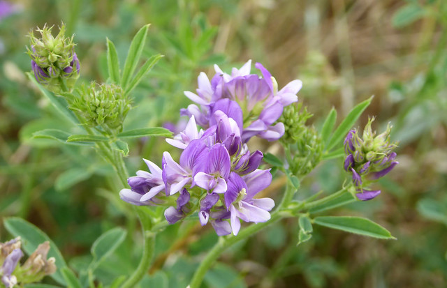
Trees surrounded the car park and bright early June sunshine filtered through the leaf cover casting dappled light across the parking area. Birdsong echoed around us and the rippling sound of running water emerged from the nearby woodland. Common vetch scrambled through the fences along the car park edge and its purplish-pink pea-type flowers were proving popular with plump, furry, pale brown bumblebees.
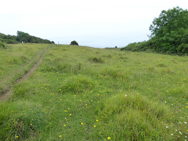
We set out along the woodland path taking a right fork to stay on the northern edge of the reserve. The track felt enclosed but wildflowers grew along the margins including the inconspicuous bright blue speedwell and the purplish-blue spikes of bugle. In time, the woodland melted away leaving the path to run between broad sloping banks topped by trees and scrub. This is the Witherstone cutting, once the path of the Bridport branch railway as it ran between Powerstock and Toller stations.
The old railway cutting
This branch Line opened in 1857 linking Bridport to Maiden Newton and the main line. The coming of the railway to West Dorset revolutionised social and commercial life in the area which, at the time, was poorly served by roads. People could travel more widely and I tried to imagine trains passing through the cutting, drawn in a haze of smoke and noise by the small steam engines of the Great Western Railway. I pictured people on the trains, travelling for work or for leisure or moving about during the two world wars. The line was also important for the transport of milk, watercress and the net and twine produced in Bridport. As motor transport came to dominate, traffic on the railway declined resulting in its closure in 1975. Although the tracks were lifted, there are still signs of the old railway, notably the rusty fence posts that line the track. The remains of an old brickworks can also be found in the nearby wood. This was set up near the railway to take advantage of the clay that remained when the cutting was excavated.
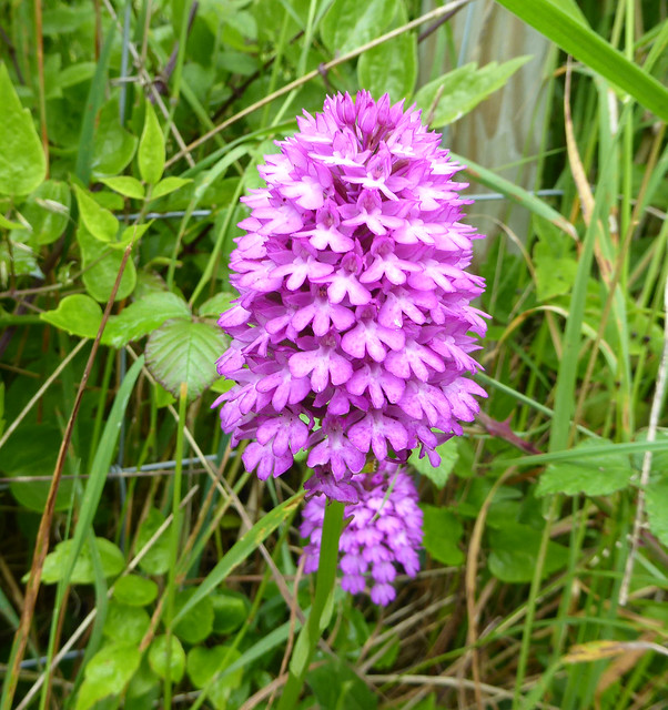
On the day of our visit, the sloping banks on either side of the path were mostly clad in short rough grass although there were some areas of exposed grey soil, perhaps a result of slippage. The former railway cutting felt very sheltered and the bright yellow flowers of bird’s foot trefoil grew across the grassy areas. We also found many small flowers of milkwort, almost hidden in the grass. Milkwort is a common plant on rough grassland and the flowers exist in several colours. Pink and purplish-blue flowers grew at Powerstock Common but each flower also had one white petal divided into finger-like lobes giving it a passing resemblance to a miniature cow’s udder. This may account for the name of the flower and its use in the past for increasing milk production. We also found one common spotted orchid with beautiful purple markings but more will have appeared, along with many other flowers, as the season advanced.
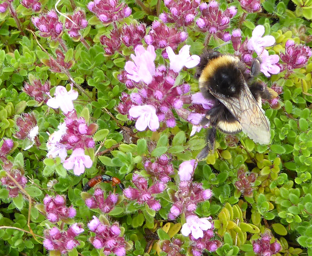
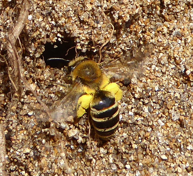
The abundance of flowers attracted insects and several common blue butterflies flew past or around us displaying their sky-blue upper wings and intricately patterned lower wings. Two yellow butterflies also passed by, dancing around one another in the air. I hoped they would land so that I could identify the species but they did not oblige. Bumblebees moved lazily among the flowers but we made our most exciting observation on a slightly raised area of rough grass with some exposed grey soil not far from the main path.
Here we found bees flying about at high speed, backwards and forwards and from side to side, just above the ground, accompanied by a clearly audible buzz. There were perhaps a hundred or more of the insects, and with their incessant movement this was an impressive sight. It was difficult to identify them at first owing to their frantic activity but they were honeybee-sized and I thought I could see shiny black abdomens. Very occasionally, one would pause to feed from the bird’s foot trefoil revealing a yellow face, a pale brown-haired thorax and two very long antennae, each as long as the rest of their body. Such long antennae, resembling shiny black bootlaces, are seen only on one UK species of bee, the male long-horned bee (Eucera longicornis).
The obvious excitement of these male bees arose because they were anticipating the emergence of females and wanted to try to mate. Indeed, on several occasions some left their frantic flying to coalesce into a small mobile cluster. Others tried to join in, some left the melee. This was a mating cluster and formed when a virgin female emerged from her nest chamber. Many males then pounced upon her hoping to mate but only one was successful. Once mated, females get on with nest building and laying of eggs to secure the population of next year’s long-horned bees.
The long-horned bee was once a common sight in May and June across the southern half of the UK, unmistakeable from the long antennae of the males. Agricultural intensification led to destruction of habitat used by these bees along with a loss of their favoured flowers such as wild vetches and peas. As a result, the species is now quite rare being restricted to twenty or so UK sites many of which are along the southern coast. The Powerstock colony is large and seems to be prospering; it was a treat to see it that day.
Powerstock Common is a rich and varied nature reserve and we glimpsed only a small part during our visit. Even so, we enjoyed the peace and the floral beauty of the old railway cutting and discovered a fascinating mixture of natural and industrial history.
At the beginning of July, Natural England announced that the combined land at Powerstock Common and nearby Kingcombe Meadows, both managed by the Dorset Wildlife Trust, would become a National Nature Reserve recognising the unique character of these west Dorset sites and the rare wildlife they contain.
The East Devon and Dorset coast in the south west of the UK, popularly known as the Jurassic Coast, was designated as a UNESCO World Heritage Site in 2001 putting it on a par with the Grand Canyon and the Great Barrier Reef. The Jurassic Coast is unique in being the only place on the planet where 185 million years of the earth’s history are sequentially exposed in cliffs, coves, and other coastal features. Since 2001, museums and visitor centres have sprung up along its 95-mile length and a fine stone sculpture, the Geoneedle at Orcombe Point, Exmouth celebrates the beginning of the World Heritage Site in East Devon. On a sunny day in early November, just before the second lockdown, I went to take a look.
The Geoneedle at Orcombe Point with the view towards the Exe estuary and Dawlish Warren
The sea front at Exmouth was quiet when I arrived, there were just a few people about taking morning walks or enjoying the beach and the sunshine. I left the car and walked to the end of the promenade where red cliffs strike out across the beach. From here, it is an easy walk up a zig zag path, past the café, to the cliff top and the area known as the High Land of Orcombe. By now, the early mist had evaporated affording spectacular views from the cliff top across the Exe estuary, Dawlish Warren and the south Devon coast as far Torquay. The mild sunny weather had also brought out late season insects including bumblebees, hoverflies and an ageing red admiral butterfly. A short stroll then took me to an open grassy area above the cliffs where the Geoneedle stands and the Jurassic Coast begins.
A hoverfly that I saw near the Geoneedle
An ageing red admiral butterfly (Vanessa atalanta)
The Geoneedle is an impressive modernist sculpture about 5 metres in height and one-metre square at the base tapering to a stainless-steel point that takes on the colour of the sky, a clear blue that day but catching the sun at certain angles. It was designed by public artist, Michael Fairfax and is constructed from three kinds of Portland stone with insets of eight different rocks representing the principal building stones found along the Jurassic Coast. The site also includes a compass showing some of the local landmarks and a Jurassic Coast hopscotch, both made from stones set into the ground. The sculpture was inaugurated by Prince Charles in 2002.
Not only is the Geoneedle a beautiful object, it also cleverly encapsulates the story of the Jurassic Coast in its design. The eight stone insets are arranged so that they correspond to the three different geological time periods of the many kinds of rock found along the 95 mile stretch of coast between Orcombe Point and Studland Bay. Starting at the bottom, the first two stone insets come from the oldest time period, the Triassic (about 250 million years ago); the hard, red rocks and softer mudstones below Orcombe Point are from this time period and were formed as sediment accumulated when the earth was an arid desert. The middle four insets are from the Jurassic period (about 170 million years ago) when southern England was under a tropical sea; some of the best-known coastal features in West Dorset, Portland and the Purbecks were laid down at this time. Finally, the two topmost insets are from the Cretaceous period (about 65 million years ago) when sea levels fell and sediments from lagoons, swamps and rivers were deposited. The Cretaceous rocks are the youngest along the Jurassic Coast and can be seen at various points notably in the white cliffs at Beer in East Devon and in the chalk stacks of Old Harry Rocks near Studland.
The Geoneedle showing the eight stone insets
Much of our knowledge of the origins of the different rocks comes from studies of the fossils and minerals found along the coast giving important information on the plants and animals that lived there and the climatic conditions prevailing during the different time periods. The findings of local geologists and palaeontologists were crucial in this and the most important of these was Mary Anning, working in the 19th century, discovering fossils dating from the Jurassic period in the mobile cliffs around Lyme Regis. Her discoveries illustrated a hitherto unknown, bygone world dominated by massive marine reptiles swimming in a tropical sea.
When I had finished looking at the Geoneedle, I walked back down the zig zag path, across the promenade and on to the beach. By now, the tide had receded leaving large swathes of pale, firm sand and the area was very busy with people, many walking dogs, all enjoying the gift of this sunny pre-lockdown day. There were even two horses with riders at the water’s edge making for a very evocative image.
The low tide made it possible for me to walk around Orcombe Point to examine the red cliffs and their rocks. Starting from the beach road, red cliffs extend at right angles up to the jagged outcrop of Rodney Point. The exposed rock here is a hard sandstone of the Triassic period with considerable honeycomb weathering caused by wind and rain. Beyond Rodney Point, red cliffs continue but there is also a very striking red rock formation, the Devil’s Ledge, a broad wave-cut platform. Orcombe Point lies a little further to the east with the Geoneedle just visible, high above. These red Triassic rocks owe their colour to iron oxides and they continue with some interruptions along the coast to Ladram Bay, Sidmouth and beyond Seaton before Jurassic rocks take over near Lyme Regis.
The red cliffs near Orcombe Point showing the downwards tilt in the strata
To the east of Orcombe Point, the hard, red sandstone is overlaid by softer rocks and the strata exposed in the cliffs exhibit a pronounced downwards tilt to the east. This tilt occurred after the Jurassic period and brought the older Triassic rocks to the surface. Cretaceous material was then deposited and, after many millions of years of weathering, the Jurassic Coast of today was created with its distinctive pattern of exposed rocks from the three time periods.
If, therefore, we take a notional walk along the entire length of the Jurassic Coast, starting at Orcombe Point and finishing at Studland Bay, we will encounter a multitude of different landforms including dramatic cliffs, stone stacks, pebble beaches and rocky coves. These coastal features, and the rocks they contain, represent an almost continuous record of 185 million years of the earth’s history, rather like the pages of a book or the travels of a time machine.
That day, of course, I had only skimmed the pages of the first chapter of the book. As I walked back to the car, though, on that mild late autumn day, I reflected on how my visit had given me a renewed sense of the importance and of the unique nature of the Jurassic Coast.
It was the video that clinched it! I’d read the reports of starlings gathering in their thousands at sunset over Chesil Beach but when I saw the video of their murmuration and the liquid patterns they carve in the sky, I knew I had to go to see for myself. So, on the first clear, dry day we set off for West Bexington on the West Dorset coast near where the starlings had been spotted.
the sun hung low in the pale western sky
West Bexington is a tiny village lying between low coastal hills and Chesil Beach and when we arrived that mid December afternoon, it all felt very quiet. The sun hung low in the pale western sky, its bright yellow disc casting a shimmering, silvery mirror across the water and a warm light across coastal fields. We parked in the beach car park and set off across the shingle, the pea-sized pebbles making for hard going as usual. The sea was our constant companion, calm with just a light swell and waves that barely left a thin white line along the vast sweep of beach. I had thought there might be more people about to watch the birds but, apart from a few fishermen, their faces turned fixedly towards the sea, we were alone on the shingle. The skeletal remnants of beach plants that flourish here in warmer months added to the sense of isolation.
For a short time, we stood by the extensive beds of pale reeds that line the back of the beach. The feathery stems fidgeted and rustled as a light breeze passed and we heard the occasional squawk from birds deep in the reeds but invisible to us. A skein of geese passed eastwards to disappear behind the coastal hills honking loudly as they went and the pale moon appeared above the ridge.
Moon rising over the ridge (photo by Hazel Strange).
Then we noticed another figure labouring across the shingle, swathed in warm shawls and a woolly hat. She approached us and asked if we had come to watch the starling murmuration. We had of course. She told us that she had seen them perform near here on the two previous afternoons before roosting and this was about the right time. We stood, the three of us now, looking, watching, scanning the sky for perhaps ten minutes, but nothing happened. We discussed the vagaries of watching wildlife and we got colder and colder. The sun, a fiery orange ball by now, approached the horizon and spread its warm glow across the shingle. The moon, nearly full and not to be outdone, rose steadily above the hills.
We were on the point of giving up when the first group of starlings appeared in the sky above the coastal hills to the west. At first, they were just a mobile black smudge but soon they began to move about in the pale sky sculpting smooth shapes and occasionally disappearing from view over the dark land. Quite suddenly they were joined by more …… and more……. and more birds, as though some signal had been sent and soon a huge cloud of thousands of birds was moving backwards and forwards forming massive, mobile, liquid shapes that twisted, thickened, thinned and sometimes split apart before merging again. The mass of birds, the murmuration, seemed to have a life of its own, as though it was some kind of sky-bound superorganism squirming about. This was one of the most impressive natural events I have ever experienced, forever engrained in my memory. It lifted our spirits eliciting spontaneous exclamations of surprise and delight.
By now the sun was setting and the light was fading. Suddenly, and without warning, the birds dropped down to roost across the coastal scrub to the west below Othona like a sheet floating to the ground; it was as if another signal had been sent that only the birds understood. With so many starlings, there must have been an impressive noise from their wings when flying and from their chattering when on the ground. I lost all sense of time while the birds were performing their murmuration but when I checked my watch the whole event had lasted only ten minutes and coincided roughly with the setting of the sun.
We marvel at their behaviour but starlings don’t create these pulsating patterns in the sky for our benefit. So, why do they do it? Security is thought to be one reason. Predator birds are always on the lookout for food and as the light fades, individual starlings become more vulnerable. They cannot see the predators well in the fading light but flying as part of large swirling mass of birds provides safety in numbers. Predators find it difficult to focus on single starlings in a moving murmuration so the chance of attack for individual birds will be lower. Starlings are also gregarious and are thought to gather in large numbers as a prelude to roosting close together both to keep warm overnight and to exchange information about good feeding areas. It is tempting after having watched a murmuration to suggest that the birds are also expressing some kind of joy of life.
And yet, starlings are not universally loved. Some people view them as noisy, thuggish and dirty creatures: bird-feeder bullies that soil urban spaces where they roost and have a negative effect on arable farming. Should you take the time to look at a starling, though, you will see a beautiful bird with glossy black plumage enhanced by flashes of iridescent purple or green. Their dark plumage is decorated with startling white spangles in the winter so that, as the poet Mary Oliver says, they have “stars in their black feathers”.
But whether you love them or hate them, starlings in the UK are in trouble. Since the mid-1970s, there has been a 66% drop in their numbers, the starling has been red-listed and is of high conservation concern. The reasons for this decline are poorly understood but are thought to be linked to changes in farming practice. The use of pesticides and synthetic fertilisers and the loss of flower-rich hay meadows have severely reduced numbers of invertebrates such as earthworms and leather jackets that starlings depend on for food. Starlings are dying of starvation and other farmland birds such as tree sparrows, yellowhammers and turtle doves have also been badly affected. Agriculture needs to adjust to make space for wildlife in order to halt this downward spiral before we lose these birds altogether and murmurations become no more than memories.
Towards the end of July, I visited the Maer, a nature reserve situated at the eastern end of the promenade in Exmouth, a seaside town in the south west of the UK. With its sand dunes and sandy grassland, the Maer is a remnant of a much larger dune system that once stretched down to the beach. Nowadays, it provides an oasis of calm close to the busy sea front as well as a habitat for special plants and insects.
sea holly growing on the sandy ridge
A slight mist softened the long views as I walked eastwards along Exmouth sea front. Some warmth penetrated the cloud and a few people were already enjoying the beach on this late summer morning. The sandy tip of Dawlish Warren lay tantalisingly close across the water and further on, the Ness at Shaldon lurked in the mist like a gigantic wedge of cheese. The commercial area with its big wheel, pubs and cafes was busy but eventually I reached a quieter part where sand and scrub tumbled downwards at the side of the beach road. This is the edge of the Maer, a local nature reserve and one of Exmouth’s hidden gems. Superficially, the Maer is a large grassy, sandy space sandwiched between the beach road and Exmouth Cricket Club but it conceals a mosaic of different environments with unusual flora and fauna.
A substantial sandy dune ridge forms the southern border of the Maer giving views across the reserve on one side and towards the beach on the other. Marram grass grows thickly giving the sand stability but there are also areas of bare sand and areas of scrub, reminders of the dune system that must have occupied this area before the beach road was built. Restharrow with its pink and white pea-type flowers and a few residual yellow evening primrose provided some colour but it was the sea holly that surprised. This is an unusual and unexpected plant that grows extensively along the first part of the ridge. Its spiky greenish-grey leaves with white margins and veins and its powder blue flowers light up the sand as though someone had spilt pale paint. Sea holly flourishes in these arid conditions by having leaves covered in a waxy cuticle to help retain water and through its deep roots. Although sea holly has some visual resemblance to our Christmas greenery, it is a relative of the carrot; in the past it was employed as an aphrodisiac.
Several large insects with bold black and yellow markings crawled about the bright blue sea holly flowers collecting nectar. These are beewolves, some of our most spectacular solitary wasps, that nest in sandy places and specialise in catching honeybees. Both male and female beewolves were feeding that day but it is the larger female (up to about 2cm long) that catches and paralyses honeybees and may be seen flying back to the nest carrying a quiescent honeybee beneath her. She digs a nest tunnel in sandy soil up to a metre long with multiple terminal branches where she lays eggs and provides honeybees as food for the developing larvae. These once rare insects have expanded their UK range since the 1980s, possibly in response to climate change and I saw them in several places on the reserve notably on a stand of mauve thistles. They are not aggressive towards humans.
Further along the ridge, before it is colonised by brambles, scrub and low trees, I found a large clump of an unruly scrambling plant covered in pea-type flowers of an impressive reddish-pink colour. This is broad-leaved everlasting pea, a perennial relative of our annual sweet pea, growing through the grasses on the Maer ridge holding on via thin tendrils. A chunky dark bee was feeding from the flowers, apparently undeterred by their jerky movements in the breeze. This was a leafcutter bee, most likely the Coast Leafcutter Bee that favours sandy habitats near the sea. They nest in burrows in vegetated sand lined with pieces of leaf cut from trees and plants. Later, when the sun came out, I saw several of these bees chasing one another around the bright pink flowers like children in a playground.
The large central part of the reserve was coated with golden brown grass criss-crossed with paths for walkers and looking very dry, a reflection of the recent lack of rain. Within the grass were mats of restharrow and many of the yellow dandelion-like flowers of catsear. One area resembled a lunar landscape with many small craters where the surface had been dug out exposing the sand. Solitary wasps and small leafcutter bees had happily nested here.
Tall clumps of ragwort with bright yellow daisy-like flowers and deeply lobed green leaves were dotted around the central area. This plant provides valuable habitat and food for invertebrates and I found one clump that had been appropriated by black caterpillars with prominent yellow bands. They were moving about, eating the leaves of the ragwort, voraciously consuming the greenery and destroying the upper parts of the plant. These are caterpillars of the cinnabar moth and as they feed, they assimilate some of the toxic alkaloids contained in ragwort, rendering themselves unpalatable to birds and other predators. It is said that their yellow stripes act as a warning to birds. Once fed and mature, the caterpillars dig themselves into the ground to spend 12 months or so as pupae before emerging as beautiful day-flying red and black moths. The adult moths live for a few weeks, feeding on nectar before mating and laying eggs on the ragwort leaves. The eggs grow into caterpillars and the cycle starts all over again. The cinnabar moth is entirely dependent on ragwort for its survival.
Towards the western end of the reserve, I found a large colony of flowering plants, perhaps suggesting damper conditions. Clumps of common mallow up to a metre tall dominated with their trumpet flowers composed of five deep pink petals each with purple stripes. At the centre of each flower was a mass of grey pollen-covered stamens emanating from a single stalk like a miniature bunch of flowers. Near the mallow, large areas were covered by a sprawling, scrambling plant richly covered with pea-like flowers above many small, spear-shaped, mid green leaves. Flower colours varied from very pale to light blue, mauve and deep purple with some plants having several of these colour variants. One plant even had bright yellow flowers. This is Sand Lucerne, a fertile hybrid of lucerne and sickle medic, naturalised in East Anglia, where its two parents grow together, but now transplanted elsewhere.
There’s so much to see at the Maer and I could easily have spent several more hours looking about. But I had a train to catch so I headed back along the promenade and across the town towards the station.
Nearly 180 years ago, about three miles west of Lyme Regis (in the south west of the UK), a huge chunk of the East Devon coast split off to form a plateau separated from the mainland by a deep, dry ravine. This was the largest movement of land ever experienced in this part of the country; it remodelled the coast and created a unique new environment. The plateau, now called Goat Island, and the ravine are still unique and when I walked there in late June, pink and purple orchids flowered across the grassy surface of the plateau whereas the ravine was populated by a tangled jungle of trees and other vegetation.
The grassy surface of Goat Island with the sea in the background
In the early 19th century, the land behind the cliffs in this part of East Devon was dominated by farming. Between the cliffs and the sea there was an area of land, the undercliff, formed by subsidence that supported fertile market gardens and orchards with some pasture for animals. Cottages had also been built here for farm labourers who walked up and down the steep cliff path to the farmhouse a short distance inland. The latter part of 1839 had seen unprecedented rain and as Christmas approached, there had been ominous signs of instability in the cliffs with deep fissures opening on the cliff tops and settlement cracks appearing in cottages built on the undercliff.
One of the farm labourers who lived in the cottages with his family was William Critchard. At about 1am on Christmas Day 1839, Critchard and his wife returned to their cottage having been generously entertained along with other labourers’ families by their master at his farmhouse. Their Christmas Eve gathering had included the West Country custom of burning the ashen faggot (a large ash log) accompanied by the drinking of copious amounts of cider. On their way back to the cottage, the couple noticed that part of the cliff path had dropped about a foot since the morning and new cracks had appeared in the cottage walls. Still merry after their evening’s entertainment they retired to bed unconcerned. At 4 am, however, they were awoken by a “wonderful crack” and by 5am they rose to find deep fissures appearing in the garden. They realised that something major was happening and set off up the cliff path, now almost impassable owing to subsidence, to spread the alarm.
Movement in the cliffs continued over the next 24 hours and as the day dawned on December 26th it revealed a landscape changed almost beyond recognition. Contemporary drawings show that a massive section of cliffs, about three quarters of a mile long and estimated as 8 million tons of rock, had moved seawards by several hundred feet creating a dry ravine, the Great Chasm, in its wake. The plateau of land that had moved was bounded by cliffs 150 feet high and came to be called Goat Island. The ravine held a gothic landscape of lumps and bumps, peaks and troughs, vividly expressing the power of the convulsion that had occurred. (See here for some contemporary illustrations of the landslip)
The cliffs in this part of Dorset and Devon are notoriously mobile, but the events of Christmas 1839 represented the greatest ever movement of land in the area. At the time there was much speculation as to the cause of the landslip: might it have been the result of an earthquake or a volcano, was it the work of rabbits, or could it have been a punishment from God? By chance, two of the most eminent geologists of the time, William Buckland and William Conybeare, were staying nearby and could interpret the events; Buckland’s wife Mary made invaluable drawings of the changed landscape. Buckland and Conybeare concluded that the excessive rain had saturated the permeable layers of chalk and greensand that constituted the upper part of the cliffs. Beneath these layers was an impermeable layer of clay and the chalk/greensand, saturated and very heavy, moved forward on the impermeable clay leading to the landslip.
The new landscape became a tourist attraction. Queen Victoria arrived on the Royal Yacht to view the scene and others took to paddle steamers to gaze in wonder while specially composed music, the Landslip Quadrille, was played. Bizarrely, fields of corn and turnips growing on cliff top land had moved intact with Goat Island and were ceremonially harvested the following August by local village maidens dressed as attendants of Ceres, the Roman Goddess of the Harvest.
But what of Goat Island nowadays? It’s only accessible on foot but the walk along the coast path is worth the effort. I set off from Axmouth on a misty but mild morning in late June to make the steep climb across the golf course and on to the cliff top. I followed narrow lanes with high banks and skirted cornfield edges to reach the coast path. Cliff edge scrub obscured the sea most of the time but occasional breaks revealed Beer Head lurking mysteriously in the mist.
About two miles into the walk, with my attention captured by the many flowers lining the path, I was jolted from my reverie as the path twisted and dropped down steeply into dense vegetation. It continued to descend with the occasional squirm to the right or left before bottoming out. About me now was a disorienting, tangled jungle of trees, shrubs and ferns with brambles and creepers dangling downwards to catch the unwary. Dampness hung in the air and only brief vestiges of light filtered through the canopy. This is the undercliff near the edge of the Great Chasm, no longer an open ravine but taken over by nature in the intervening 180 years.
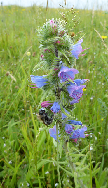
Quite soon the track reared upwards again climbing steeply towards the light past a cushiony chalk hillside with a scattering of wild flowers. In time, the path levelled out to a long, lush grassy meadow sloping gently towards sheer cliffs above the undercliff and the sea; this is Goat Island. Woven within the grass were the frilly flowers of eyebright, many yellow dandelion-like flowers of catsear, patches of yellow rattle and wild thyme and two blue spikes of viper’s bugloss. It was, however, the orchids that surprised me with their number and variety: pyramidal orchids with their intensely pink, three-lobed petals overlapping like ornate roof tiles and common spotted orchids with their cylinders of lilac pink flowers carrying magenta hieroglyphics. I searched for bee orchids and found only two spikes, each bearing several flowers. With their mauve propeller-like sepals and their large central petal complete with furry edges and yellow horseshoe patterns on a maroon background, these flowers are one of nature’s marvellous mimics said to resemble bumblebees. Butterflies, especially marbled whites completed the scene. Goat Island nowadays is a beautiful, unusual place, an oasis of calm where noise means bird song. It is also a managed landscape, a cooperation between nature and humans, as every year the grass is mown to encourage flowers and to prevent scrub taking back the land.
Goat Island is also a place of history and I stood there for some time, trying to imagine the scene 180 years ago when the land beneath my feet moved and the lives of the people living there were changed forever.
The picture at the head of this post shows common spotted orchids and catsear on Goat Island.
The Cirl Bunting is an attractive songbird once found throughout the southern half of the UK. Its numbers declined precipitously in the second half of the 20th century following changes in farming practice and, by the late 1980s, it was confined to coastal farmland in south Devon and might have become nationally extinct. The Royal Society for the Protection of Birds (RSPB) recognised the problem and worked with farmers to support the bird resulting in a dramatic increase in its numbers. In a recent expansion of its range the bird has established itself in East Devon at Stantyway Farm near Otterton having been absent for more than 30 years. I wanted to find out more so I went to Stantyway to see for myself.
Male cirl bunting (photo generously given by David R White)
Female cirl bunting (photo generously given by David R White)
The Cirl Bunting was first reported in the UK by Montagu in the winter of 1800 near Kingsbridge in south Devon in the west of the country. It is roughly sparrow-sized and the male, in particular, is very distinctive with its black and yellow striped head and olive-green breast band. The bird gradually spread across the southern half of the UK, its numbers peaking in the early years of the 20th century. Since then it has declined and by the late 1980s only 118 pairs remained, confined to coastal farmland between Plymouth and Exeter.
With the Cirl Bunting facing national extinction, the RSPB identified changes in farming practice linked to agricultural intensification as responsible for the precipitous decline. In the winter, the bird forages for insects and spilt grain in weedy stubble fields. In the summer, it nests in hedges or scrub and forages on unimproved grassland rich in invertebrates with grasshoppers being important food for chicks. With agricultural intensification, there was a shift from spring-sown cereals to autumn sowing so that far fewer arable fields were left as winter stubble; grubbing out of hedges took away nest sites and loss of the hay meadows and increased use of pesticides reduced invertebrate numbers and summer food for the bird.
Once the cause of the decline had been identified, the RSPB worked with farmers in south Devon to support the birds by reinstating some traditional agricultural practices, supported by government agrienvironment schemes. The effect was spectacular and by 2016, numbers of Cirl Buntings had increased to over 1000 pairs. Most of the increase occurred in the bird’s core range but there was some spread along the coast and inland where habitat was suitable. This was a major conservation success, also benefitting other species.
The coast of south Devon showing the core range of the cirl bunting and the location of Stantyway Farm across the Exe estuary in East Devon (from British Birds).
The bird has a reputation for being sedentary and it had been assumed that the estuary of the river Exe would be a barrier to further eastwards expansion of its range. So, it was a surprise when, around the end of 2010, a single Cirl Bunting was seen at Stantyway Farm near Otterton in East Devon followed by several more sightings early in 2011. Since then, the numbers at Stantyway have increased suggesting that the local conditions suit the birds and from 2015 it was clear that a breeding population existed.
Stantyway Farm is owned by Clinton Devon Estates and when the tenant, Mr Williams, retired in 2014, the farm was taken back into Clinton’s own Farm Partnership. Clinton Devon Estates were keen to support Cirl Buntings and other species on their arable farm at Stantyway so they took advice from the RSPB and applied for agrienvironment support. This was awarded in 2016 and supports planting hedges to provide more nest sites, leaving wildlife margins around fields to provide invertebrates as summer food, and planting spring cereal crops that are harvested in the autumn leaving weedy winter stubbles with seed as food. These are all activities shown to be critical in supporting these birds in south Devon. The farm was also put into organic conversion in 2016; organic farming by its nature supports wildlife and increases invertebrates. Cirl Bunting numbers at Stantyway gradually increased across this time.
In 2017, Clinton Estates advertised for a new tenant farmer at Stantyway and Sam Walker was appointed. Although the farm is still mainly arable, Sam keeps 52 cows whose calves are raised and sold on to beef finishers. About a third of the land is now devoted to grass for silage production for winter animal feed. Sam has, however, embraced the existing philosophy of the farm in supporting wildlife: he has maintained the organic status and intends to apply for further agrienvironment support when the current scheme runs out in 2021.
I wanted to see the farm for myself so, on a mild early April day, I went to Stantyway. I left the car on the rough ground across from Stantyway Farmhouse and stood for a few moments enjoying the sunshine. The air was filled with the endlessly inventive song of the skylark and occasionally a buzzard mewed as it circled lazily overhead. Sometimes a low buzz cut through all of this and when I looked, I realised this was from all the insects about.
I walked away from the farm along the gentle downhill slope of Stantyway Road with views developing over rolling East Devon countryside on one side and to the hazy mid-blue sea on the other. The lane descended between wide grassy verges backed by luxuriant hedges. Spring flowers grew through the thick grass including stitchwort, celandine, dandelions, violets and white dead nettle. The dominant flowering plant was, however, alexanders, with its fleshy green stems, copious shiny dark green foliage and pale mop head flowers. This was proving very popular with many kinds of fly and a selection of solitary mining bees, some collecting large lumps of white pollen on their back legs.
My walk included a long section of the coast path skirting the edge of Stantyway fields. Thick scrubby hedges, mainly flowering blackthorn, lined the cliff edge along with more alexanders. The occasional hedge break afforded spectacular views along the red cliffs of the Jurassic Coast towards Ladram bay with its crumbling stacks, past the white elegance of Sidmouth and finishing in the chalk of Beer Head (see picture at the top). Again, there were many solitary mining bees taking advantage of the flowers. I did not see any Cirl Buntings on my walk but, on two occasions I heard their distinctive, rattling, metallic trill telling me the birds were about.
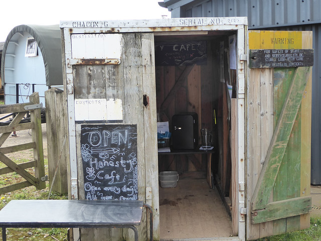
It’s a beautiful place made all the better by glorious early April weather and I was surprised to see so many insects along the paths. Perhaps this reflects the methods used at Stantyway, showing that productive farming and wildlife can coexist and prosper. Around the farm, each field gate has an information board giving the crop and some other useful information. An Honesty Café has been installed near the farmhouse providing continuous hot water for tea or coffee and homemade cakes that I can strongly recommend. All of this suggests an outward looking, open approach to farming. When I met Sam Walker, the farmer, he explained that, in addition to the provisions of the agrienvironment scheme, he has put skylark plots in cereal fields, created wild bird seed corridors and put up swift boxes to support wildlife. I came away feeling that at Stantyway, Cirl Buntings were getting the best support they could. His methods have already benefitted other farmland birds with numbers of skylarks and reed buntings doubling over the past year and in a further twist to the Cirl Bunting story, some of the birds have now been seen to the east of Sidmouth.
I should like to thank Sam Walker, Doug and Joan Cullen, Kate Ponting and David White for generous help in preparing this article which appeared in the May edition of the Marshwood Vale Magazine.
One of the farm gate signs
Alexanders (greenish-yellow) and blackthorn (white) along the coast path. The cliff edge is behind the hedge!
A solitary mining bee (probably Andrena flavipes) feeding from blackthorn.
A solitary mining bee (probably Andrena nitida) feeding from Alexanders
This is a long post describing how a group of concerned people, including myself, noticed some unusual plastic pellets appearing on several beaches in the vicinity of Charmouth in west Dorset in the south west of the UK. After a tortuous investigation, we identified the source of the plastic pellet pollution as a local water company carelessly and unnecessarily discharging the pellets into the sea.
The story started on a sultry day in late July 2017. I was driving back from the Wareham area where I had been walking across one of the remaining fragments of Thomas Hardy’s Egdon Heath, the fictional landscape that plays so important a part in his novel The Return of the Native. I found myself approaching Charmouth, a small village in west Dorset and decided I needed a cup of tea. Charmouth village lies a short distance inland from the sea and Charmouth beach is popular with families in the summer, the cliffs are famous for their fossils and in her novel Persuasion, Jane Austen refers to “its sweet, retired bay, backed by dark cliffs”.
I was the only customer in the Bank House Café that afternoon and as I waited for my tea, I noticed some copies of the village magazine, Shoreline. I picked one up and started to leaf through. It’s an interesting read but my attention was taken by an article about “nurdles” written by Eden Thomson, a volunteer at the local Heritage Centre that organises marine and fossil events. I quickly learnt that nurdles are pre-production plastic pellets used as easily transportable raw materials in the plastics industry where they are used to make many of the plastic goods we have become accustomed to. There is considerable loss of these pellets during transport and during use. Some of these lost pellets end up in the sea and Eden reported finding large numbers of turquoise pellets on the beach at Charmouth with light grey and dark grey also being common. I didn’t have time to go to the beach to look that day but my curiosity was piqued.
Looking for pellets
Now, when we walked on beaches, both Hazel and I looked to see if we could find any plastic pellets. It took me a while to get my eye in, Hazel saw them more quickly, but gradually I noticed a few pellets on most beaches. My first big find was at Leas Foot Sands near Thurlestone in south Devon after some hefty storms in mid October 2017 where hundreds were sprinkled along the strandlines. These were all 5mm or less across, some were lentil shaped and translucent, many were cylindrical and grey and a few were irregular grey and black with clear ridges. By reference to the Great Nurdle Hunt web site I reckoned most were nurdles but a few might be biobeads (see below).
Plastic pellets found on Leas Foot Sands among natural debris (October 2017)
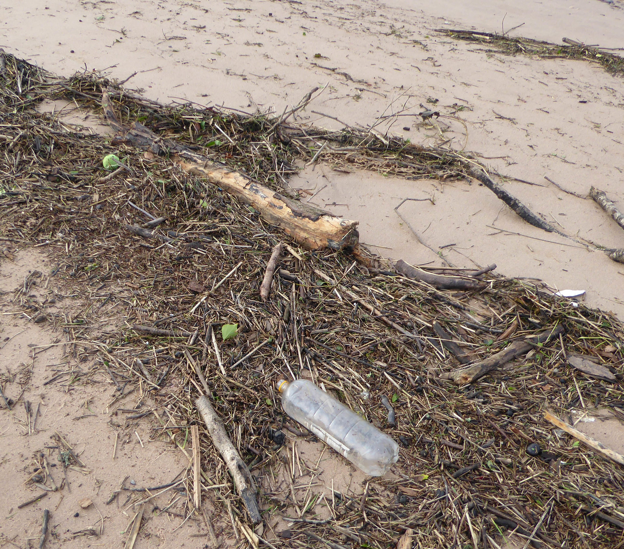
Then in late October 2017 I had a chance to return to Charmouth and look at the beach. Not only was there a lot of general plastic pollution among reedy/woody debris either side of the river Char where it approaches the beach, but among this debris were many plastic pellets. There were a few of the translucent or yellow or green lentil shaped pellets, also some grey or black cylindrical pellets. Most of these were nurdles. Also, as Eden Thomson had described, there were many bright blue cylindrical pellets. When I examined these, I felt they were quite different from other pellets I had seen; in particular they had many fine ridges and I thought they might be biobeads (see below). We returned to Charmouth in January 2018 and again found many of the bright blue ridged pellets littered around the two sides of the river and on the car park edges. We also made a brief visit to West Bay, about 7 miles to the east of Charmouth and found many bright blue ridged pellets there as well.
Debris along the east side of the river Char (October 2017)
Close-up view of debris showing blue ridged biobeads, some black biobeads are visible if you look about
A sample of pellets collected at Charmouth in October 2017 showing the preponderance of blue ridged biobeads. Some yellow and some translucent lentil-shaped nurdles and some grey cylindrical nurdles are also present
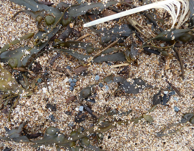
Dawlish Warren is another beach where we find plastic debris especially after storms and we had a look for pellets in March 2018. We found them distributed along both inner and outer beaches, they were mostly cylindrical, pale blue, grey and green but there were a few knobbly dark grey pellets, some also having ridges. We also found a few of the bright blue ridged pellets seen at Charmouth.
Trying to understand
In trying to understand these observations, I was greatly helped by the influential report from the Cornish Plastic Pollution Coalition (CPPC) lead by Claire Wallerstein. The CPPC had found huge numbers of black plastic pellets further west along beaches in Cornwall and, following extensive investigation, showed that these were biobeads, plastic pellets used in some sewage plants to promote sewage digestion and water purification. Biobeads are usually ridged or knobbly to provide a greater surface area for bacteria to grow and help digest the sewage. The CPPC showed that most likely the biobeads they found on beaches were escaping from biobead-dependent sewage plants run by South West Water, the local water purification and sewage company.
Based on their findings, I worked out that I was collecting both nurdles (preproduction plastic pellets) and biobeads. For the most part when I collected pellets from beaches in Devon, I found mixtures of nurdles of different shapes and colours together with a few black knobbly biobeads. At Charmouth and West Bay in Dorset, however, the predominant pellet was bright blue, cylindrical with fine ridges, typical of a biobead. There were definitely also some black knobbly biobeads on the beach at Charmouth. The four pictures below showing samples of pellets collected from two regions of Dawlish Warren beach in Devon and two sides of Charmouth Beach illustrate these differences quite well.
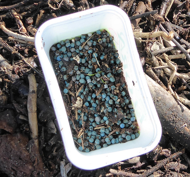
Pellets collected at Dawlish Warren (November 2018) between groynes 2-3. Note many translucent and yellow nurdles together with some black knobbly biobeads and a few blue ridged biobeads
Pellets collected at Dawlish Warren (November 2018) between groynes 9-10
Pellets collected at Charmouth (January 2019) from the beach on the east side of river Char. Note the preponderance of blue ridged biobeads, also some black knobbly biobeads and a few translucent and yellow nurdles.
Pellets collected at Charmouth (January 2019) from the beach on the west side of the river Char.
So, did South West Water (SWW) have a role in the biobead pollution appearing on Charmouth beach? The company runs a sewage works in nearby Lyme Regis based on biobead digestion. The actual works is located in Sleech Wood above the town but the purified sewage effluent is discharged into the sea some distance off the town of Lyme Regis below the Cardinal Buoy. I began to develop a working hypothesis whereby SWW uses these blue biobeads and probably also the black knobbly equivalent in their Sleech Wood works but containment of biobeads is incomplete and some are discharged into the sea and are washed back on to Charmouth and West Bay beaches. Another possibility was that pellets were being lost into the river Lim, which passes near the sewage works, to enter the sea with the river water.
A Nurdle Hunt
In the meantime, I took part in a nurdle hunt on Charmouth Beach organised by Sophie Thomas from the Charmouth Heritage Centre one Saturday in February 2018. There were 30 nurdle hunters on a bright sunny morning including Eden Thomson who wrote the article in Shoreline Magazine and it was good to meet her. It was also good to meet blogging friend Sarah West from Transition Town Bridport and her husband John. Altogether we collected 6650 pellets many of which were bright blue biobeads although a few black knobbly biobeads were mixed in with the blues. It is my impression that the black type may often be ignored in favour of the much more visible bright blue pellet.
One nurdle hunter’s haul
I wrote an article for the local Marshwood Vale Magazine describing the nurdle hunt and its background. This was published in May 2018 and soon after, I was contacted by Joe Hackett of Transition Town Bridport who had organised a beach clean at West Bay (seven miles east of Charmouth) and found many bright blue pellets there. He had noted the similarity between the pellets found at West Bay and Charmouth and wondered if we could discuss the situation. We spoke by phone and have been in contact since then.
Frustration
In March and April 2018, I became very frustrated at my inability to tie down the nature and the origin of these blue and black biobeads. I had contacted various academic experts, pressure groups and one local plastics company to ask if they could help me understand the nature of the pellets and the background to what was going on. I was very surprised to find that none of these people was prepared to get involved. Of all the people I contacted, only one replied and she was “too busy to help”.
I did investigate one possible hypothesis, namely that the biobeads were being lost from the Lyme Regis sewage works into the river Lim. I walked along the river Lim in Lyme Regis to see if any pellets were visible at the river’s edge but found none suggesting that this route was unlikely. When I talked to Joe Hackett, it turned out he had done the same accompanied by local environmentalist, Horatio Morpurgo. They also found nothing suggesting that pellets were not being lost in to the river Lim. This meant that most likely the biobeads were being discharged into the sea along with the treated sewage.
Claire Wallerstein from the CPPC offered to ask SWW what biobeads they used at their Lyme Regis sewage works and was told, “we don’t know and it would cost too much to use a crane to lift the lid to check”.
I enter the South West Water labyrinth
In desperation, I contacted the South West Water (SWW) Press Office in May 2018 and my enquiry was forwarded to Paul McNie, Environmental Manager of Waste Water Customer Service & Networks. I received a reply from Gavin Lincoln, Wastewater Treatment Process Consultant, asking what I wanted to know. I sent him a list of questions about biobead-dependent sewage treatment including asking what type of biobead was used at Lyme Regis but heard nothing. After discussions with Joe Hackett and Horatio Morpurgo, I wrote a paper letter to McNie in July 2018 asking about the nature of the biobeads used at the Lyme Regis Sewage Works. This occasioned a reply from Sue Richards, Customer Manager for SWW towards the end of July introducing herself as my dedicated case manager (it felt as though my enquiry ranked at about the same level as a leaking water pipe). I received a second letter in early August from Katie Hudson, also a Customer Services manager telling me that Paul McNie would be in touch about my queries. He never did get back to me and the rest of my interactions with SWW were through Sue Richards who, although courteous and helpful, appeared to be poorly briefed as she made some obvious errors of fact in her letters to me. The saga continued in this vein but she did reveal that the biobeads used at Lyme Regis were “black with a hint of blue” and after I asked what this meant she sent me a low-resolution photo printed on letter paper showing the biobeads used there. They all appeared to be black and strongly resembled one class of biobead found at Charmouth as well as the majority of those found by CPPC in Cornwall. I spoke to Sue Richards by phone several times and raised the issue of the blue biobeads only to have the conversation closed down quickly.
To summarise, SWW told us three contradictory stories:
They didn’t know the nature of the biobeads used at Lyme Regis sewage works (via Claire Wallerstein)
The biobeads used are black with a hint of blue
The biobeads used are black and knobbly
This was all very confusing and I was left not knowing what to believe.
Living the high life – visits to the sewage works
In the meantime, Joe Hackett had been busy organising visits to Exmouth and Lyme Regis sewage works as it was felt that this was our last chance to understand what was going on. The Cornish Plastic Pollution Coalition had visited the Plympton sewage works early in 2017 and found biobeads littered about the site. This was a key piece of information linking poor biobead housekeeping by SWW at the Plympton sewage works to the extensive biobead pollution on Cornish beaches.
The Exmouth visit took place in November 2018 but I was unable to be there. Those that visited had an interesting time and learnt about the basics of the biobead sewage treatment. They did not find any biobeads loose on the site but noticed a huge pile of used/depleted biobeads, the size of two buses, covered with sheeting. The SWW representative expressed his frustration over the problems the company faced with biobeads in the following admission “If we’d had a crystal ball back in the 1990s and could have seen how controversial plastics would have become, we might not have gone down this road”. I believe this was a reference to the pressure put on the company by Claire Wallerstein and the CPPC over losses of biobeads from the Plympton sewage works.
The Lyme Regis visit took place in February 2019 and a large group of us representing Transition Town Bridport, Charmouth Heritage Centre, Litter Free Coast and Sea Dorset, together with individuals each with their own interest gathered at the site in Sleech Wood. We were welcomed by two representatives of SWW, Rhidian Howells and Stephanie Jones who were both courteous and helpful. Rhidian Howells explained how the automated process removed large items from the crude sewage and then passed the remains through the biobead reactor where bacteria digested it. Ultraviolet irradiation completed the treatment and the effluent was then discharged to the sea. He went to some trouble to explain how SWW was installing new filters on all their biobead plants to make sure that biobead loss was minimised. The installation of these extra filters is a direct result of the work of Claire Wallerstein and the CPPC identifying the source of biobeads on Cornish beaches as South West Water.
Two blue biobeads found on the ground at Lyme Regis sewage works
Black biobeads found on the ground at Lyme Regis sewage works
While we were looking about the biobead reactor area, one of our party found a few of the bright blue ridged biobeads on the ground. A little later, someone found a clutch of black knobbly biobeads on the ground near the parking area. This immediately answered the question about the source of the biobeads on Charmouth beach: despite what SWW had told us we now knew both black and blue biobeads were used at the Lyme Regis sewage works (Howells confirmed this) and were most likely escaping from the reactors to end up in the sea. I became very angry with Howells at this point; as I explained to him, we had spent so much time and energy trying to identify the source of the biobead pollution at Charmouth. South West Water had fed us contradictory stories, when all along they knew the source of the pollution which was their own sewage works.
Chemical analysis of pellets
The Cornish Plastic Pollution Coalition biobead story featured on a special edition of Inside Out South West on BBC TV in October 2018. The programme included visiting Dr Andrew Turner at the University of Plymouth where he had been analysing pellets for Claire Wallerstein for potentially toxic elements. I wondered if similar analysis might help understand the Charmouth blue pellets so I contacted Dr Turner. I was most grateful when he replied quickly and in the affirmative. I made two special collections, one at Dawlish Warren and another at Charmouth and I also sent him some of the black biobeads picked up at the Lyme Regis sewage works.
While this was in progress, Dr Turner along with Claire Wallerstein and Rob Arnold published a paper detailing X-ray fluorescence analyses of nurdles and black biobeads collected at a variety of locations in the south west (including Plympton sewage works and several Cornish beaches) and elsewhere along the English Channel. The technique identifies potentially toxic elements in the pellets and, whereas nurdles were usually devoid of these contaminants, the black biobeads contained varying quantities of lead, bromine, cadmium and antimony, a chemical signature characteristic of recycled electrical equipment containing flame retardants. Sometimes the levels exceeded permitted levels rendering the pellets toxic and potentially hazardous to life.
Black biobeads collected at Dawlish Warren, Charmouth and at Lyme Regis sewage works had the same chemical signature (bromine and antimony and sometimes lead and cadmium) as the black biobeads collected at Plympton sewage works and along Cornish beaches. This shows that the same black biobead is used by SWW at different sewage works and is escaping to end up on local beaches in Cornwall, Devon and Dorset. Nurdles found at Dawlish Warren and Charmouth (lentil shaped and smooth, cylindrical) did not hold any toxic element contamination whereas the blue biobeads found at Charmouth contained copper probably part of the blue pigment used to give the distinctive colour.
I am most grateful to Andrew Turner for supporting us by analysing these pellets.
Conclusions
The source of the black and blue biobeads polluting Charmouth and West Bay beaches is the Lyme Regis sewage works run by South West Water where these pellets are escaping with treated sewage effluent to be discharged into the sea.
The black biobead is the same pellet found along beaches in Devon and Dorset and in huge numbers on Cornish beaches, it is made from recycled electrical equipment and may contain toxic levels of trace elements. South West Water is responsible for this extensive pollution.
Subsequent investigation found that the blue ridged biobead is also found at Burton Freshwater beach (a mile east of West Bay, found by Joe Hackett) and on the main sandy beach in Lyme Regis (about 2 miles west of Charmouth, found by Harry Dennis of Surfers Against Sewage). The pellets found on these beaches almost certainly come from the Lyme Regis sewage works
One sample of pellets that I collected from Westcombe beach near Kingston in south Devon showed surprisingly large numbers of the blue ridged biobeads. Perhaps this can be explained by proximity to SWW’s biobead-dependent sewage works at Modbury.
At Charmouth, West Bay and Lyme Regis, these biobeads are found in parts of the beach where children play in the summer. They are also found at Charmouth by the river where both gulls and ducks feed so it seems very likely that these birds will be accidentally ingesting pellets.
South West Water are installing extra filters at their biobead-dependent plants to minimise pellet loss as a result of the efforts of the Cornish Plastic Pollution Coalition. Providing that programme is completed and is successful, the number of biobeads on local beaches should diminish. This of course does not deal with the reservoir of biobeads now in the sea and also buried in sand. It is very difficult for me to see how these pellets can be cleaned up without damaging the fabric of the very beaches we wish to protect.
Greater legal protection for the marine environment should be introduced so that companies like SWW who release biobeads, also plastics companies that release nurdles could be prosecuted for polluting seas and beaches.
I should like to express my thanks to everyone who helped bring this tortuous story to a conclusion.
The new geology gallery showing the ichthyosaur and plesiosaur skeletons on the left. (courtesy of Lyme Regis Museum)
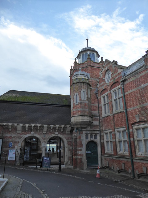
The Lyme Regis Museum reopened last year after a major makeover including the addition of a new wing named after Mary Anning, the famous fossil hunter and one of Lyme’s most celebrated citizens. Mary Anning possessed a unique talent for finding, reconstructing and interpreting fossils in the cliffs of west Dorset and her discoveries transformed the field of geology in the 19th century. The new Mary Anning Wing has transformed the Museum into one fit for the 21st century.
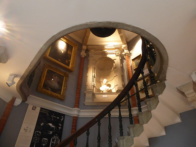
I remember visiting the Museum some years ago on a bitterly cold mid-December day. I recall a pretty but rather spartan Victorian building crammed with interesting exhibits but very much a museum in the old style. I returned this January to a completely different experience. The Museum now has a spacious, welcoming entrance area and shop with natural light flooding through plate glass windows giving spectacular views across Lyme Bay and the Jurassic Coast. The important features of the old building such as the beautiful spiral staircase and rotunda are still emphasised but there is a new Fine Foundation Learning Centre and with the installation of a lift, the Museum is accessible to all.
I enjoyed the bright, interesting and well-presented galleries covering the Early History of Lyme, the Cobb and the Sea, the Undercliff, Lyme during the War and the Branch Line Railway. A large display on Literary Lyme features, in particular, the writer John Fowles, who lived in the town and was a great supporter of the Museum acting as Curator for a decade. Fowles’ novel “The French Lieutenant’s Woman” was famously made into a film putting Lyme on the international map. Jane Austen also features strongly; she spent holidays in the town and set some of her novel “Persuasion” there.
All this alone is worth the price of admission but, in my opinion, the real jewel in the crown is the new interactive Geology Gallery. Here the visitor can see fossils similar to those discovered locally in the 19th century that changed the face of geology forever and made Lyme Regis famous around the world. The Gallery celebrates these discoveries and the people who made them while not forgetting those who continue this quest into the 21st century.
The large, high-ceilinged room is packed with exhibits: many different kinds of fossil, drawings, artefacts and mementoes. There are striking examples of large fossilised creatures on the walls and suspended above are models of these same creatures. The exhibits are so impressive and so well presented that there is a strong “wow factor” but the interactive displays bring the exhibits to life showing what the fossilised bones mean and what these creatures might have looked like. It is a gallery for all ages but there is no dumbing down.
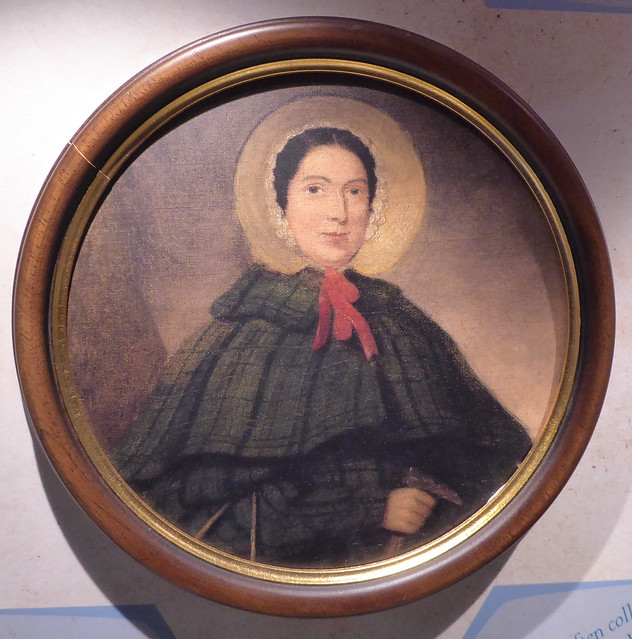
Mary Anning (from picture in Lyme Regis Museum)
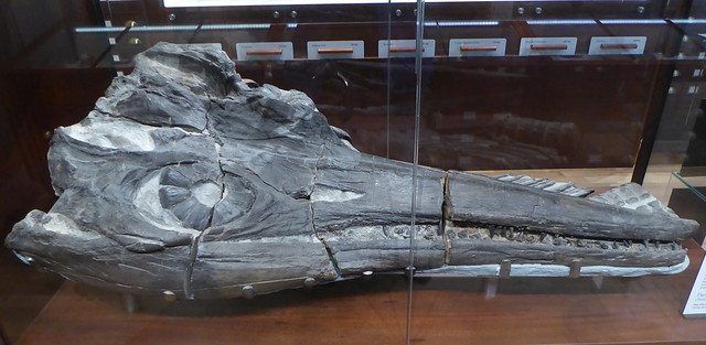
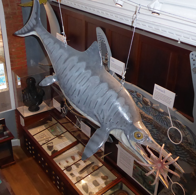
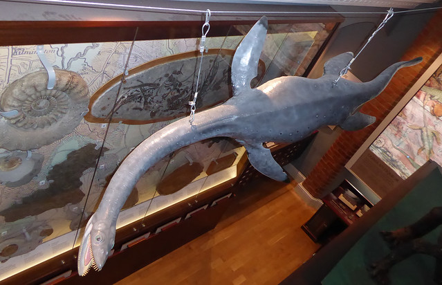
As I looked around the Gallery, I felt that even if she wasn’t actually there by my side, Mary Anning “spoke to me” from almost every exhibit. Her story is outlined in the displays, how she was born in Lyme Regis in 1799 to a very poor family, received no formal education but learned from her father the way to collect fossils from the surrounding cliffs. When she was about 12 years old, she and her brother made their first major fossil discovery, an Ichthyosaur, a now extinct “fish-lizard”. One of the most dramatic objects on display in the Gallery is a partial Ichthyosaur skeleton, about 5 metres long, discovered in 2005 by Paddy Howe, the Museum geologist, similar to the one discovered by Mary Anning. There is also a massive fossilised Ichthyosaur head in one of the cabinets, so we can get a real sense of how exciting it must have been to discover one of these creatures for the first time. Mary went on to become the greatest fossil hunter ever known, possessing a unique skill and persistence in finding and reassembling fossils together with the intelligence to learn about the underlying science. Among her other unique fossil discoveries were two Plesiosaur skeletons, the first ever found and probably her greatest finds. The Plesiosaur was a small-headed marine reptile with a very long neck and the Gallery contains the skeleton of a juvenile Plesiosaur with a model of the creature hanging above the display.
Despite her lack of formal education and her humble origins, Mary came to be well respected by the leading geologists of the time, Henry de la Beche, William Buckland and William Conybeare, all of whom are described in displays. These men sought her out in Lyme and befriended her but despite this friendship, they used the fossils she found to further their own reputations and gave her little or no credit. As a woman in the 19th century, she was never able to assume her rightful place in the scientific hierarchy. After she died in 1847, however, Henry de la Beche read a eulogy to the Geological Society dedicated to Mary Anning and her discoveries. This was an honour usually accorded only to fellows of the Society which did not admit women for another half century.
The new Gallery tells the story of Mary Anning but I feel that her importance is slightly underplayed, especially in relation to the male scientists of the time. Her discoveries were unique, showing that large reptile-like creatures had existed millions of years ago but were now extinct. These findings challenged existing ideas in geology and questioned contemporary biblical accounts of creation. They also contributed to changes in thinking that led Charles Darwin to propose theories of evolution by natural selection. The importance of Mary Anning should not be underestimated and it is surely significant that in 2010 the Royal Society voted her one of the 10 most influential women in science.
I very much enjoyed my visit to the remodelled Lyme Regis Museum with its new Mary Anning Wing. It is a treasure trove of fascinating displays, a museum fit for the 21st century, and the staff should be congratulated on their achievement. I urge you to visit, you will not be disappointed.
Lyme Regis Museum
Spiral staircase, Lyme Regis Museum
Ichthyosaur head in Geology Gallery, Lyme Regis Museum
Model of Ichthyosaur above Geology Gallery, Lyme Regis Museum
Model of Plesiosaur above Geology Gallery, Lyme Regis Museum
The picture at the top of this post shows a model of a pterosaur in the Lyme Regis Museum. Mary Anning found the first skeleton of a pterosaur outside continental Europe.
I wasn’t sure what to expect today. Major engineering work had been carried out at Dawlish Warren over the past year to stabilise the beaches and dunes and this was our first visit since the project had been completed. I hoped the area hadn’t been changed too much as it’s a special place.
Dawlish Warren is a massive sand spit that extends north-eastwards for about 2km across the mouth of the River Exe from its western bank. It reaches out like a giant hand towards the town of Exmouth but fails to make contact, leaving a narrow channel where tides and the waters of the Exe flow in vast amounts each day. The sand spit is about 500m wide but incomplete; a huge bite has been taken out of the inner side creating the inland bay, leaving the tip of the spit, Warren Point, attached by a thin strip of dunes. Some of the recent stabilisation work was aimed at strengthening this dune strip against future increases in sea level. Much of the Warren is now a nature reserve with several rare habitats including vegetated dunes, mud flats and salt marsh and has been designated as a Site of Special Scientific Interest.
Aerial view of the Dawlish Warren sand spit, showing the inner bay and the dune strip connecting to Warren Point, also the proximity to Exmouth at the top. (from the Exeter Daily)
The Warren was once used for breeding rabbits for food, hence the name, but with the arrival of the railway, it became a popular holiday resort. It now also has a golf course, fun fair, shops, cafes and a pub although these are concentrated at the western end and do not detract appreciably from the nature reserve.
Despite heavy overnight rain, the day was dry, and warm for the time of year (11 degrees) but feeling cooler in the stiff sea breeze. Layers of dark cloud dominated the sky but occasional linear shafts of sunlight broke through towards the steel-grey sea. There were clear views from the promenade along the outer sea-facing beach with its many groynes and across the water to Orcombe point, the start of the East Devon/Dorset Jurassic Coast.
We left the promenade via a boardwalk descending to the central, low-lying part of the reserve, once a tidal lake but long since filled in. Today the area was puddle-strewn and barren; later in the year, it will be a colourful mosaic of wild flowers. A large pond with wildfowl lay behind a tree screen where an exquisitely pink male bullfinch showed for a while. On the water, two swans performed like synchronised swimmers.
A sandy track led us up to the marram grass-fringed path along the crest of the outer dunes with views over the golf course and inner bay to the north and across the outer sandy beach and sea to the south. A large flock of Brent Geese were feeding on one of the greens, no doubt to the irritation of the golfers. Dropping down to the inner bay we walked along the stony foreshore, finding it littered with large amounts of debris, mostly wood and reeds but also industrial pellets and shards of plastic.
On one side of the inner bay there is a large bird hide that looks across mud flats and salt marsh at low tide. Huge numbers of waders can be seen here. Yellow gorse sparkled near the hide together with several small stands of flowering ragwort; fuzzy, lime green lichen coated some bushes. From the hide, we watched ghostly black cormorants on a mud bank spreading their wings to dry and saw hundreds of oystercatchers huddled together, the colours of their plumage merging into discrete layers of black and white. A little egret flew across displaying its yellow feet and a curlew probed the mud with its long curving beak.
From the inner bay we accessed Warren Point and the soft sandy beach that leads around the tip of the sand spit. At the back of the beach there were dunes clad with marram grass, a subtle mixture of green and yellowish-brown spikes. This part of the Warren is both strangely beautiful and unsettling and as we circled the Point, we were conscious of the vast amounts of water passing at the foot of the sloping beach and the apparent proximity of Exmouth just across this turbulent channel. Again, there were huge amounts of debris on the beach, wood and reeds predominantly but mixed with plastic including more industrial pellets. On the inner beach, we also saw as many as eight green tennis balls, many plastic bottles, several golf tees and many fresh green leaves. I presume this waste had come down the Exe propelled by the heavy rain that had fallen inland over the past few days. Once we had rounded the Point and started walking back along the outer beach, the nature of the debris changed and we saw mainly plastic rope and twine, probably fishing-related.
By now it was mid-afternoon and the low tide gave us the chance to walk below the end of the newly reinstated groynes that stalk, triffid-like, across the wide sandy beach. The sea was calm but the gentle waves were enough to satisfy a lone, silhouetted surfer. Then, for a few minutes, the low sun broke through the layers of grey cloud, casting an intense yellow light across the dunes at the back of the beach, creating a mysterious, unnatural landscape where, surrounded by pink sand, the marram grass had turned to gold. At the same time, the western view was filled with an intense white light, bleaching grey out of the cloud and sprinkling silver across the sea.
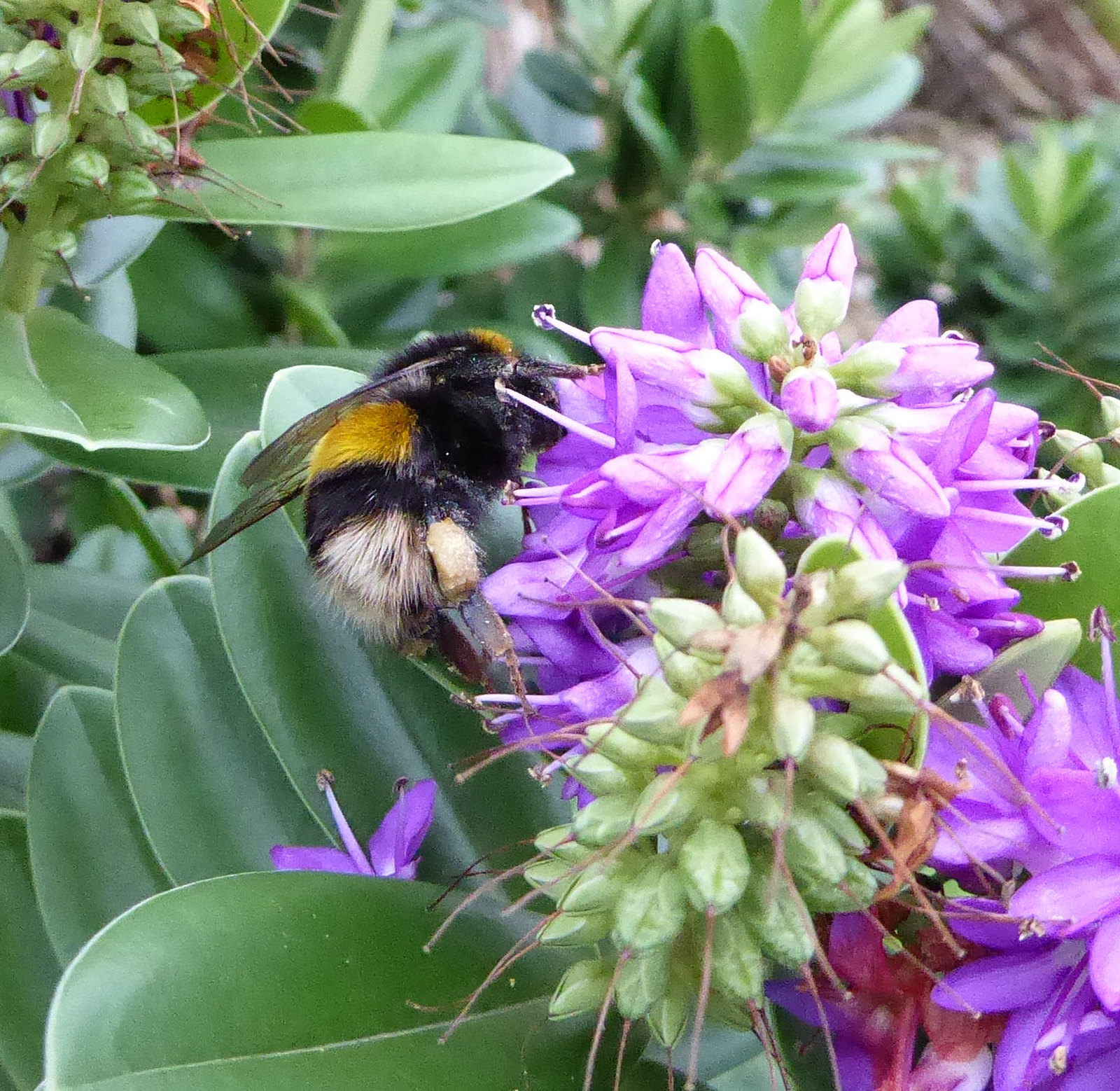
Eventually, we reached the commercial part of the Warren where the mystery might have ended, but there was one final treat in store: a queen buff-tailed bumblebee as large as my thumb, collecting pollen from purple Hebe, presumably to stock her nest.
My concerns about the effects of the engineering work turned out to be mostly unfounded. Only one part of the Warren is visibly different, the narrow dune strip which is now topped with bare sand. The area has, however, been planted with marram grass which will take over in time. Overall, Dawlish Warren remains a special, elemental place.
The featured image shows the outer beach and groynes viewed from the dune strip, with, in the distance, Orcombe Point and the start of the East Devon/Dorset Jurassic Coast .
We visited Dawlish Warren on January 22nd 2018.
Shafts of sunlight breaking through
The sandy dune path with views over the golf course
Cormorants on mud bank, river Exe – with friend
Oystercatchers on mud bank, river Exe
Debris on the sandy beach approaching Warren Point with dunes and marram grass to the right and Exmouth ahead
beach debris
beach debris with several industrial pellets
Looking across the channel to Exmouth from Warren Point. The sand bears the marks of strong currents from the morning’s high tide combined with excess flow of water down the Exe
The sun turns the marram grass to gold
The sun breaks through – bleaching grey out of the cloud and sprinkling silver across the sea
Queen buff-tailed bumblebee on shrubby purple hebe
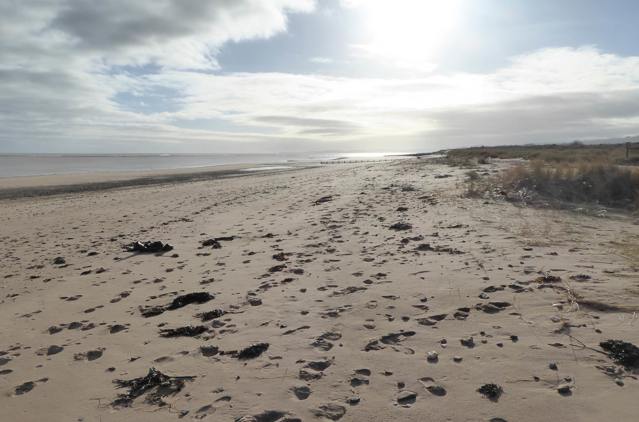
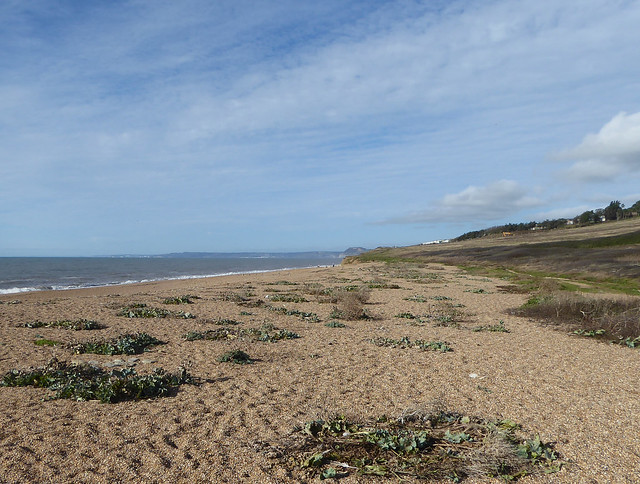
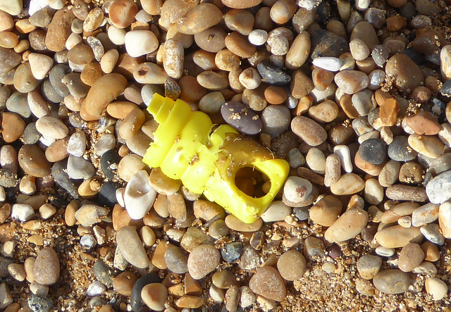
Towards the end of October, I spent a day at Cogden Beach, just east of Burton Bradstock in west Dorset. It’s a beautiful, natural spot, a rich concoction of sea, sky and shingle where wildlife prospers despite the sometimes harsh conditions. It’s becoming increasingly difficult, however, to ignore the scatter of plastic pollution on the beach and the potential effects of this manmade material on marine life.
Looking west along Cogden Beach towards Golden Cap, showing the clumps of sea kale and yellow horned-poppy
It felt unseasonably warm as I walked downhill from the car park, more like a late summer’s day, although the blood-red rose hips and smoky-black sloes decorating the leafless scrub spoke of a different season. The vast shingle bank of Chesil Beach dominated the long view, a yellowish-brown convexity edged with white waves sweeping eastwards towards a mistily mysterious Isle of Portland. The sea was calm and a steely grey except where the low sun’s rays highlighted individual wavelets whose reflections merged in to a broad, silvery band of light.
When I reached the shingle bank I found traces of the special beach plants that grow so profusely here in spring and summer. Well weathered, blue-green and brownish-grey leaves were all that remained of the sea kale that dominates in May whereas, beneath the brown remnants of this season’s vegetation, fresh glaucous leaves were showing from the yellow horned-poppies. Small flocks of starlings skittered about puddles at the back of the beach like children in a school playground and, in a low sandy cliff, I was surprised to find bees busily filling nests. These were ivy bees (Colletes hederae), the last of our solitary bees to emerge, the females collecting chrome-yellow pollen from nearby clumps of flowering ivy. To the west, there were spectacular views of Burton Bradstock’s yellow cliffs and the distinctive flat top of Golden Cap.
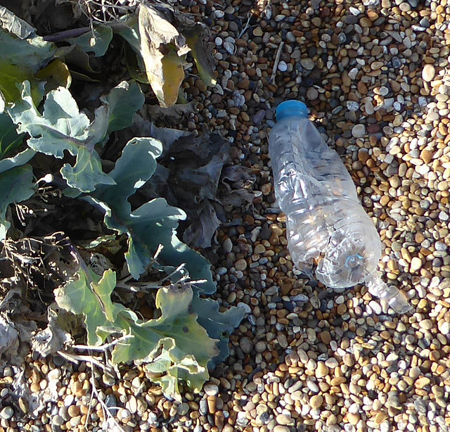
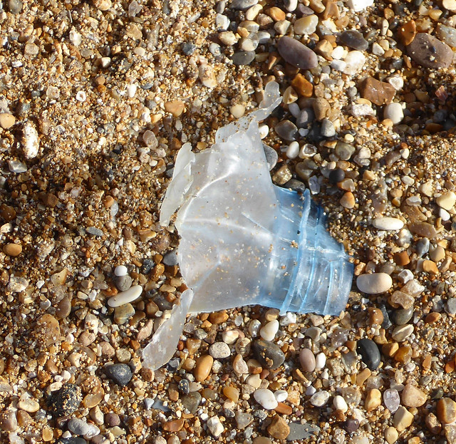
It seemed like the perfect natural spot. But was it? Almost all the clumps of beach plants contained plastic waste including pieces of plastic wrap, colourful plastic rope or plastic fishing line. On the shingle between the clumps, I saw the occasional plastic drink bottle, some were intact, some in pieces. The prominent strandline about half way up the beach contained dark, dry seaweed and small pieces of wood mixed liberally with shards of plastic as though objects had shattered in their continual buffeting by the sea. Plastic drink bottles or their fragments also appeared at regular intervals along the strandline. This beach is no longer a completely natural, wild place, it has been contaminated by our throwaway plastic culture. Perhaps the most poignant symbol of this tension was a chunk of expanded polystyrene covered with pale grey goose barnacles.
Plastic is, of course, both versatile and cheap. It has transformed our lives but its very ubiquity and ease of use means that we don’t value it enough. Think how much you throw away each week: plastic wrap or bags from supermarket produce, drink containers and lids, plastic trays, pots and so on. We have embraced a “disposable” lifestyle where about half of the plastic we produce is used once and thrown away. Some countries manage to recycle or energy-recover a large proportion of their plastic waste but the UK is not one of them. In this country, more than 60% of plastic waste ends up in landfill where it does not break down and is effectively lost. We are squandering resources and energy on a massive scale, an appalling indictment of our way of life.
But what about the plastic waste I found on Cogden Beach, how does it get there? It comes from the sea and is left behind by the retreating tide. We have turned our oceans into a “plastic soup” composed of plastic bottles and bags, plastic fragments formed by breakdown of these larger items, also microplastics (5 mm or less in size) such as industrial pellets, small fragments and very small fibres from clothing or from car tyres. This is a huge global problem and shows no sign of abating. A staggering 12 million tons of plastic waste enters the oceans each year. All countries contribute but a large proportion comes from several in the Far East with poor waste management systems.
The consequences for marine wildlife are alarming. Consider, for example, the Northern Fulmar, a bird that forages exclusively at sea. A study in the North Atlantic showed that 91% of dead Fulmars found on beaches had plastic in their gut, having mistaken the plastic for food, reducing their ability to feed and sometimes damaging their digestive tract. At the other end of the food chain, zooplankton have been shown to ingest tiny microplastic fragments that may end up in fish and perhaps in humans. Plastic fragments also attract toxic chemicals that may affect the creatures consuming them. Our throwaway lifestyle is disturbing the entire global marine ecosystem. The problem is just as serious as climate change.
What can be done? First, we must reduce the amount of plastic in circulation by moving away from single-use items such as plastic bottles, takeaway cups, plastic cutlery, plastic wrap and plastic packaging. The introduction of the 5p charge on plastic bags led to an 85% reduction in use, so a levy on single-use takeaway cups and plastic cutlery may also be effective. Second, we need to encourage a “circular economy” where as much plastic as possible is recovered and recycled and none goes to landfill. A deposit return scheme for plastic drink bottles would increase recovery but greater recycling of other plastic containers must also be achieved. It is encouraging that some government ministers are now talking about the problems of plastic waste, but their words must be translated into actions.
Individual decisions can also bring about change. We can refuse to use plastic cutlery. We can choose to drink only from reusable cups. We can use and reuse our own shopping bag. We can recycle all plastic bottles and containers. We can pressurise local businesses to reduce plastic waste. We can participate in beach cleans. If we love our beaches and our seas we must do this.
Plastic bottle and sea kale on Cogden Beach
A well-travelled plastic bottle remnant on Cogden Beach
New growth on yellow horned-poppy, with plastic bottle
Plastic waste on Cogden Beach
Goose barnacles on expanded polystyrene
Low cliffs at Cogden Beach with ivy bee nests
Female Ivy bee (Colletes hederae) returning to her sandy burrow with pollen, at Cogden Beach